
Poor biking weather today didn't stop me from riding, but it did considerably shorten the ride's length. The weather forecast from the previous day suggested spotty showers picking up in the afternoon. When I woke up this morning, I checked on the window. The overcast skies and wet street looked unpromising, but no one on the sidewalk carried an umbrella so after breakfast and a little reading I headed out with the intent of reaching Plymouth Meeting and the hope to go as far as Ambler, 30-40 miles roundtrip.
Full Screen Version
A light, but tolerable, rain fell as I started on the city streets toward the Schuylkill recreation path. Many other people braved the uninviting weather. About two miles out the rain intensity increased, not to a heavy rain, but strong enough to ruin a ride. Rather than turn around, I opted to press forward at least as far a East Falls, and then double back on the opposite side of the ride. By the time I reached East Fall, the rain ceased. I didn't take the bait. I turned south into a warm, forceful headwind, back toward downtown Philadelphia. In the end I rode hardly more than 10 miles, probably a third of it in discomforing rain, but I glad I managed to get at least that much today.
Current Weather Status: people are using umbrellas.
Statistics
Length: 12.4 miles
Ride Time: 59 minutes
Total Time: 59 minute
Avg. Speed: 12.4 MPH
Max. Speed: 16.6 MPH
Avg. Cadence: 66 RPM
Cumulative Ascent: <100 ft.
Max. Elevation: <100 ft.
Saturday, October 31, 2009
Monday, October 26, 2009
Yellowstone 2009
In May of 2006, I took, as I consider it, my first serious vacation. By serious, I mean, more or less, that I flew somewhere, rented a car, and stayed away for at least week. The destination was Yellowstone National Park. Since then, I must have visited everything else there is to see, because, when planning to squeeze one trip in this year I found my way back to Yellowstone. Not to put to fine, I put on it, but I do see the return to trodden ground as a milestone for me, someone for whom much of travel's lure is the opportunity to explore new areas. In truth, I spent most of the trip visiting virgin territory outside the park. Even once in Yellowstone, I spent more time climbing new trails, than in previously visited areas.
Full Screen Version
Whereas on my first trip I flew to Denver, this time around I landed in Salt Lake City, which is closer to the park. In fact, it was the the cheap, direct flight to SLC that first lured me to that airport. Only after purchasing the plane ticket did I opt for an itinerary leading to Yellowstone. Once on the plan, I discovered an added bonus. Delta had equipped it with a fancy entertainment system that allowed me to play trivia against other passengers or watch live TV on the small screen built in to the seat in front of me. I did well on the trivia, winning quite a few rounds, but not earning the high score for the day. Sadly, ESPN was one of the few live TV channels that didn't work so I couldn't watch the Thursday night college football game.
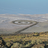
I spent the first day and half taking an indirect route to Yellowstone. Along the way, I stopped at a number of sites, including Spiral Jetty, Golden Spike NHS, Logan Canyon Scenic Byway, and the Teton Dam ruins. Once in Yellowstone, I stretched my legs on a six mile hike up and down Purple Mountain, before heading to the geyser basins for the rest of the day. I followed a similar pattern on Sunday, hiking up Mount Washburn in the morning and wandering about Norris Geyser Basin in the afternoon. It culminated on Monday with my most ambitious hike, the 3,000ft climb to Amphitheater Lake in Grand Teton National Park, after which I drove back to Salt Lake City to catch an early Tuesday morning flight back to Philadelphia.
(This photo album contains all the pictures used in the Google Map. You can also see any picture by clicking on a blue pin and following the direct link to the that picture in the album.)
.
Full Screen Version
Whereas on my first trip I flew to Denver, this time around I landed in Salt Lake City, which is closer to the park. In fact, it was the the cheap, direct flight to SLC that first lured me to that airport. Only after purchasing the plane ticket did I opt for an itinerary leading to Yellowstone. Once on the plan, I discovered an added bonus. Delta had equipped it with a fancy entertainment system that allowed me to play trivia against other passengers or watch live TV on the small screen built in to the seat in front of me. I did well on the trivia, winning quite a few rounds, but not earning the high score for the day. Sadly, ESPN was one of the few live TV channels that didn't work so I couldn't watch the Thursday night college football game.
I spent the first day and half taking an indirect route to Yellowstone. Along the way, I stopped at a number of sites, including Spiral Jetty, Golden Spike NHS, Logan Canyon Scenic Byway, and the Teton Dam ruins. Once in Yellowstone, I stretched my legs on a six mile hike up and down Purple Mountain, before heading to the geyser basins for the rest of the day. I followed a similar pattern on Sunday, hiking up Mount Washburn in the morning and wandering about Norris Geyser Basin in the afternoon. It culminated on Monday with my most ambitious hike, the 3,000ft climb to Amphitheater Lake in Grand Teton National Park, after which I drove back to Salt Lake City to catch an early Tuesday morning flight back to Philadelphia.
 |
| Yellowstone Photo Album |
(This photo album contains all the pictures used in the Google Map. You can also see any picture by clicking on a blue pin and following the direct link to the that picture in the album.)
.
Sunday, October 25, 2009
Heinz NWR
I started my ride heading in direction I don't often take, south through streets of South Philadelphia. I try to avoid a lot of biking in the city. The streets are narrow and debris-ridden. It is also hard to get in a good rhythm with all the stopping that is required. But today it felt like a nice change of pace from my usual routes out of town. Crossing the drawbridge on Passayunk Avenue, one of the few exits from the area, was a bit nerve-wrecking, but other than that it was smooth sailing all the way to the Heinz Wildlife refuge in extreme southwest Philadelphia.
Full Screen Version
When I set out, I didn't intend to ride through the refuge, but it turned about to be a good destination. The fall colors still pretty vibrant, if a little passed their peak. It was nice to get off-road, and enjoy some quite riding for a short while. I don't get much opportunity to do that around here.
When I left the refuge, I was as far from my apartment as I would get. I headed north, as true as the roads would allow, stopping in a small strip center my company owns. Once in Springfield, I started heading west, first along quite residential streets lined with houses all prepped for Halloween; then, I caught Garrett street, a minor artery that headed straight in to Philadelphia.
All in all it was a pretty easy ride without much climbing. I hoped for 40 miles, but ended up clocking just under 30. Depending on the weather I hope to get at least one, maybe two, more ride(s) in before the weather gets too cold and the days too short.

Statistics
Length: 29.3 miles
Ride Time: 2 hours 41 minutes
Total Time: 3 hours 00 minute
Avg. Speed: 10.9 MPH
Max. Speed: 24.9 MPH
Avg. Cadence: 60 RPM
Cumulative Ascent: 850 ft.
Max. Elevation: 267 ft.

Train passing over Snyder Street on Elevated Tracks in South Philadelphia

Trail in John Heinz National Wildlife Refuge

Heinz National Wildlife Refuge

Philly Skyline over marsh in Heinz NWR

Deer on trail in Heinz NWRefuge
Tuesday, October 13, 2009
Mosquito Range Hike
I spent the lion's share of the last day on my Colorado Rockies vacation hiking the Mosquito Mountain Range south of Breckenridge. In planning my vacation, I had reached out to my longtime friend Dan Hadley, who currently lives in Boulder. He came up with the idea of hiking a few fourteeners, mountain peaks with elevations in excess of 14,000 ft.
We rendezvoused at a lodge in Breckenridge, twenty or so miles from the trailhead, Dan drove us to the trailhead the next morning. We left around a quarter to six, stopped for breakfast at a gas station in Fairplay, and arrived at the trailhead, after official sunrise time, but before the sun actually rose over the mountains surrounding us. The last five miles of the journey covered a progressively degenerating dirt road.
The trail started over weathered-white rocks at the outlet to Kite Lake, a name whose logic is evident from higher elevations, and proceeded through an unoccupied campground. At 12,000 feet we were well above tree-line, but green grass covered the ground at the start. As they grass gave way to the talus of the mountainside, the gentle ascent quickly evolved to a serious climb that notified my lungs I wasn't at sea-level anymore.
Full Screen Version
As we proceeded, a group of college kids at least thirty-strong started on the quiet trail behind us. They would stretch out based on ability so that beginning about an hour into the hike and continuing to the first summit I always seemed to be in their company or that of other hikers as they overtook me. Dan for his part proceeded ahead of me ten to fifty yards before stopping to let me catch up. Registering a whooping average speed of 1 MPH, we reached the saddle between Mt. Democrat and Mt. Cameron, a good place for a short rest, after an hour and half or hiking.
After a ten minute rest on the remnants of some mining operation, we took the left fork of the trail up the last 700 feet of Mt. Democrat. An hour later when I set foot on the USGS marker at this mountain's peak, I had officially summitted my first fourteener. We rested there among the crowd (20-30 people) for about twenty minutes, but it felt like half that to me.
Most people satisfied with reaching this peak, return to the parking lot from here, but we wanted to continue on to Mt. Lincoln, the highest peak in the Mosquito Range. To reach this 14,286 ft. mountain, we backtracked to the saddle where we had rested early and continued on the right fork of the trail up the west slope of Mt. Cameron, an extension of Mt. Lincoln (to be an independent mountain, a peak must rise at least 300 feet above the saddle that connects it to the nearest peak) . Simon Cameron, a senator from Pennsylvania, was Lincoln's first secretary of war, though I don't know if this fact played into the name of the peaks. All told we had lost and regained about 700 feet of the orginally gained 2,000 in elevation, between Mt. Democrat and Mt. Cameron. We unnecessarily wandered around the top for Mt. Cameron trying to devine which point was the highest on the broad peak.
After all the exertion, I enjoyed the short section between Mt. Cameron and Mt. Lincoln for it was comparably flat. Moreover, Mt. Lincoln projects like a prow from the line of the other mountains. Consequently, the forward views here were more open compared to the pile of rocks leading to the previous peaks. Lastly, Mt. Lincoln represented, not only the most distant point on the hike, but also the tallest mountain I would ever climb. Arriving at the summit around 12:30 we had made pretty good time, but not enough for more than another twenty-minute break for the common threat of late afternoon thunderstorms prompts wise hikers to be off the mountains by 3:00 PM.
With 3.5 miles of trail ahead of us, we set off for Mt. Bross, the last fourteener on the route. Mercifully the ridge to this last summit only drops 400 ft before beginning the to rise again. Indescribably exhausted by this point in the hike, I resorted to taking twenty steps forward before resting for 10 deep breaths. I repeated this pattern until I reached the summit (a broad-topped mountain like Mt. Cameron) at around 2:00 PM.
With dark clouds in the vicinity, we spent very little time on this last peak. Considering that it really was all downhill from here, I didn't mind the abbreviated visited. The menacing skies aside I was happy to to expedite completion of the hike, but not the point I didn't enjoy the great views, particularly of Mt. Democrat, the peak I had climb how many thousand steps ago.
Dan seemed more hurried on the descent. Trusting his experience, I traveled as fast as I could bear, but even walking down hill takes energy. I found the worst parts of the entire trail were on the top half of Mt. Bross. At times it seemed the trail slanted laterally 30 to 40 degrees. At others, the rocks felt so loose I'd sink up to my ankle in dirt and fear riding a rockslide the rest of the way down the mountain. Halfway down, we dropped from exposed ridge to semi-protected gulch and Dan seemed to relax. I anxiously sought the return of the green grass at the base of the valley. The clouds continued to gather and dropped a but a few sprinkles. The trail had one last surprise for us, the a 15-ft cascade hidden in a small cleft at the end of he gulch, a half mile or so from the parking lot.

Trip Statistics
Length: 8.0 miles
Time: 8 hours 3 minutes
Elevation Change: 2,286 feet
Total Climbing: 3,700 feet
Max. Elevation: 12,286 feet
Sunday, October 11, 2009
Back on My Bike
After more than a month, since labor day, in fact, I got back on my bike for a serious ride. I don't count the aborted ride in mid-September. Despite the long layoff, I managed a respectable 40 mile ride out to Fort Washington State Park. I intended only to ride for two hours in order in order to make it back to town with time to take care of some business, namely spend a few extra hours at work. But, equipment problems delayed my start a half-hour. More importantly, I had fantastic weather for the ride, though I could have used a sweatshirt. Recognizing that I had but a few days left in the year to ride, I pressed further than my original plan, riding for about four hours total.
Full Screen Version

Statistics
Length: 42.0 miles
Ride Time: 3 hours 58 minutes
Total Time: 3 hours 51 minute
Avg. Speed: 11.3 MPH
Max. Speed: 26.5 MPH
Avg. Cadence: 56 RPM
Cumulative Ascent: 2050 ft.
Max. Elevation: 422 ft.
Full Screen Version

Statistics
Length: 42.0 miles
Ride Time: 3 hours 58 minutes
Total Time: 3 hours 51 minute
Avg. Speed: 11.3 MPH
Max. Speed: 26.5 MPH
Avg. Cadence: 56 RPM
Cumulative Ascent: 2050 ft.
Max. Elevation: 422 ft.
Wednesday, October 7, 2009
Glenwood Canyon
Glenwood Canyon escorts I-70 through the last major mountain range heading west across Colorado. This highway is relatively young by interstate standards. Construction crews completed work on it in early 1990s. Along the way, they took extra steps and spend a lot of extra money to protect the canyon scenery and ecology. Though not a convenient way for my to get from point A to point B, I, in essence, made driving the length of this highway a stop in its own right.
Full Screen Version
[BN: The steep walls of the side canyon wrecked havoc on my GPS receiver. Hence, the track for the hike is riddled with error]
I would have been content to drive the canyon, but a little research revealed several trails depart from the multiple rest areas built along the highway. I chose a good leg-stretcher in Hanging Lake trail. Pulling in to the empty parking lot a little before 9:00 AM, I prepped for a tranquil hike only to see a mini-van pull up a few moments later. I started on the flat recreation trail which led to the true trailhead. The couple caught up to and passed me as I read the trail sign at the trailhead.
Immediately, the trail began steeply ascending up a side canyon. I passed the couple and didn't see them again until my descent (It turned out they went back to their mini-van for some forgotten medicine.) The trail follows Dead Horse Creek to a fork well up in the canyon. From there, it leaves the canyon floor following the rough edge of a point separating the forks in the canyon. At the top of this last steep climb, it reached the namesake Hanging Lake, a good sized pool fed by multiple cascades on the far side. A boardwalk crossed the near side with the lake to the left and a steep, but wooded drop-off on the right. I continued up the canyon a short distance beyond the end of the official trail and found some great views, but missed side-trail to spouting rock in the process.


I continued past Hanging Lake along a unofficial trail to a high point on the edge of the canyon where I could look back on the side canyon and across Glenwood Canyon to the highlands beyond.


At the bottom of the trail, the side canyon opened into the main canyon. From the still elevated trail, I got a good view of the Colorado River flowing through the Glenwood Canyon.

The trailhead for the Hanging Lake Trail lay about a half-mile west of the parking area. Connecting the two was this recreation trail that runs the length of the canyon.


Full Screen Version
[BN: The steep walls of the side canyon wrecked havoc on my GPS receiver. Hence, the track for the hike is riddled with error]
I would have been content to drive the canyon, but a little research revealed several trails depart from the multiple rest areas built along the highway. I chose a good leg-stretcher in Hanging Lake trail. Pulling in to the empty parking lot a little before 9:00 AM, I prepped for a tranquil hike only to see a mini-van pull up a few moments later. I started on the flat recreation trail which led to the true trailhead. The couple caught up to and passed me as I read the trail sign at the trailhead.
Immediately, the trail began steeply ascending up a side canyon. I passed the couple and didn't see them again until my descent (It turned out they went back to their mini-van for some forgotten medicine.) The trail follows Dead Horse Creek to a fork well up in the canyon. From there, it leaves the canyon floor following the rough edge of a point separating the forks in the canyon. At the top of this last steep climb, it reached the namesake Hanging Lake, a good sized pool fed by multiple cascades on the far side. A boardwalk crossed the near side with the lake to the left and a steep, but wooded drop-off on the right. I continued up the canyon a short distance beyond the end of the official trail and found some great views, but missed side-trail to spouting rock in the process.

Though it was not a long trail, the Hanging Lake trail was a very steep trail. I took this picture very near Hanging Lake about a 1,000 up and a bit more than a mile from the trailhead.

My destination for the hike, Hanging Lake.

I continued past Hanging Lake along a unofficial trail to a high point on the edge of the canyon where I could look back on the side canyon and across Glenwood Canyon to the highlands beyond.

Hanging Lake Trail along Dead Horse Creek

At the bottom of the trail, the side canyon opened into the main canyon. From the still elevated trail, I got a good view of the Colorado River flowing through the Glenwood Canyon.

The trailhead for the Hanging Lake Trail lay about a half-mile west of the parking area. Connecting the two was this recreation trail that runs the length of the canyon.

From the recreation trail, you can look across the river to see the east portals of the middle set of tunnels along the interstate highway. They are called the Hanging Lake Tunnels

Approaching the easternmost of the tunnels on in the canyon. The eastbound lanes, in which I'm driving, actually go around the same promontory that the westbound lanes tunnel through.

It was so pretty that this guy couldn't stay on the road. He's probably taking a picture. Some People!
Monday, October 5, 2009
Dillon Pinnacles
Nearly two days in to my Colorado Rockies vacation and I had yet to complete a respectable hike. That changed with my trip down the Dillon Pinnacles trail in Curecanti National Recreation Area. At four miles and without much elevation gain, it was a relatively easy hike.
Full Screen Version
The trail started from a small parking area just before US-50 crossed a long bridge to the south shore of the Blue Mesa Reservoir. At the beginning, it followed the gentle contours of the lake before entering a small gulch where it gained most of it's elevation. The last part of the trail was a small loop directly in front of the namesake Dillon Pinnacles, which looked quite amazing in the early evening sun.

About halfway, the trail dipped into this gulch and proceeded to climb a couple hundred feet up the hillside until it was right under the Pinnacles.

I took this picture from the near the very end of the trail, where the trail came closest to the the pinnacles.

Heading out, the trail pointed toward the namesake pinnacles. On the way back, it treated me to sun-bathed views of Blue Mesa Reservoir and the surrounding landscape. The start of the Lake City Cut-Off, my route from the park, climbs on the opposite shore of the lake.

The part of the trail closest to the parking area hugged the edge of reservoir, which is Colorado's largest lake.
 All that hiking and it turns out the best views came along side the main highway. The end of Pinnacles trail is on the prominent hill between the Pinnacles and the reservoir in the in middle of the picture.
Trip Statistics
Length: 3.9 miles
Time: 1 hours 31 minutes
Elevation Change: 356 feet
Max. Elevation: 7,870 feet

Full Screen Version
The trail started from a small parking area just before US-50 crossed a long bridge to the south shore of the Blue Mesa Reservoir. At the beginning, it followed the gentle contours of the lake before entering a small gulch where it gained most of it's elevation. The last part of the trail was a small loop directly in front of the namesake Dillon Pinnacles, which looked quite amazing in the early evening sun.
About halfway, the trail dipped into this gulch and proceeded to climb a couple hundred feet up the hillside until it was right under the Pinnacles.
I took this picture from the near the very end of the trail, where the trail came closest to the the pinnacles.
Heading out, the trail pointed toward the namesake pinnacles. On the way back, it treated me to sun-bathed views of Blue Mesa Reservoir and the surrounding landscape. The start of the Lake City Cut-Off, my route from the park, climbs on the opposite shore of the lake.
The part of the trail closest to the parking area hugged the edge of reservoir, which is Colorado's largest lake.
All that hiking and it turns out the best views came along side the main highway. The end of Pinnacles trail is on the prominent hill between the Pinnacles and the reservoir in the in middle of the picture.Trip Statistics
Length: 3.9 miles
Time: 1 hours 31 minutes
Elevation Change: 356 feet
Max. Elevation: 7,870 feet

Sunday, October 4, 2009
Monarch Pass
Halfway across Colorado, invested in the middle of the Rocky Mountains, I crossed the Continental Divide via Monarch Pass, elevation 11,312. At the top of the pass, on the left, I was attracted to an roadside attraction, an aerial tram ride promising a scenic ride to the mountaintop. I stopped to investigate. At a cost of just $7, I readily secured passage for the short ride to the summit.
Full Screen Version
Encased in my little, suspended bubble, I rode to the top of the Monarch Ridge, about 300-ft above the pass. At the top, a large look-out building protected me from the cold winds and threatening weather. I did venture out on the balcony to take a few shots of the surrounding mountains, with the best views off to the east and northeast where the tallest mountains rose beyond a small ski area. I toyed with the idea of hiking back down to the car, but in the uncertain weather I was easily convinced to return on the tram, a pretty fun fallback mode.

How could I not stop for this?

On the tram

The panorama from the top. Click on the image for a larger view.
Friday, October 2, 2009
Planes, Trams, and Automobiles
Or more accurately, an incline plane, aerial tram and automobile.
Envious of the tourists flocking to Colorado Springs after boosters there built the road up Pikes Pike, Denver citizens followed suit building a road to the top of slightly-taller Mount Evans. Disadvantaged in this scenic arms race, with no 14,000 foot mountain to ascend, Canon City denizens instead looked down in to the Royal Gorge. Acquiring the adjacent land from the federal government, they built a suspension bridge over the gorge, and immediately added a incline plane to the canyon floor. Today the park still exists with additional attractions including an aerial tram crossing just down stream from the suspension bridge.
Full Screen Version
Though the entrance fee is steep ($22 with coupon), I, ever the sucker for superlatives, paid it to walk across the world's tallest suspension bridge. Surprised by the additional attractions I spent a little more than two hours at the park, finishing with a slow drive across the marquee span.

An incline plane takes passengers down to the bottom of the canyon...

...and an aerial tram whisks passengers across the chasm...

...but the parks raison de etre is a suspension bridge spanning to gorge, reportedly the tallest in the world 1,053 ft to the river below.

Looking down from the aerial tram.

The incline plane....

... to the bottom of the canyon.
Thursday, October 1, 2009
Pikes Peak
I spent most of my first day in Colorado driving to the top of Pikes Peak, my first trip above 14,000ft. A few afternoon thundershowers almost scuttled my visit, but they cleared out in time for me to make the drive to the summit. Since, it was my first day I was hardly acclimated to the thin air at the higher elevation, but even if I could scamper all over the peak, I could enjoy the views. Not to mention the fun of driving to the top of the mountain along a very scenic road.
Full Screen Version
Full Screen Version
Subscribe to:
Comments (Atom)